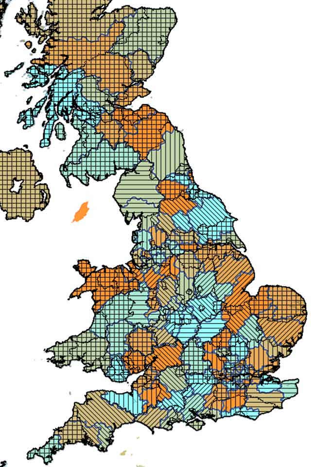
What is administrative geography?
Administrative geography is a way of dividing the country into smaller sub-divisions or areas that correspond with the area of responsibility of local authorities and government bodies. These administrative sub-divisions and their associated geography have several important uses, including:
- Judicial: defining jurisdiction of county courts, magistrates courts and assizes
- Electoral: splitting the areas up into constituencies for local, national and international government
- Administrative: mapping boundaries of local councils and administrative bodies
- Demographic: national census data is recorded by individuals. Census reporting is at the Output Area level (circa 120 households)
- Public health: helps in the planning of service provision in healthcare
"Administrative geography is concerned with the hierarchy of areas relating to national and local government in the UK, and this multi-layered hierarchy is complicated by the differing structure in each constituent country of the UK. In addition, the boundaries of many of the layers in the hierarchy are subject to either periodic or occasional change."
Office for National Statistics:
A Beginner's Guide to UK Geography
Administrative areas ensure that each public body has a clearly defined area of responsibility, which can be measured and budgeted for appropriately. Three separate offices oversee the control of the geographies and publication of data that use them:
- ONS (Office for National Statistics) for England and Wales
- NRS (National Records Scotland) in Scotland
- NISRA (Northern Ireland Statistics and Research Agency) in Northern Ireland.
Administrative geography vs postcode geography
In a similar way to postcode areas, administrative geography has evolved organically, just over a much longer period. As such, a lot of the borders seem almost arbitrary as they have been defined over hundreds of years according to priorities at the time. Additionally, there are multiple layers to the geography to accommodate local, regional, and national areas of responsibility, and each sub-division has been built up in different ways for different purposes, during different periods.
To make the system workable, borders are often reviewed, either as a rationalising measure or to take account of population, social, or governmental changes. This brings its own uncertainty as areas change and make old maps obsolete.
Any resemblance to postcode geography is fleeting. Postcodes are a much more recent development and were developed for a single reason - to administer postal deliveries (see our postcode blog for more on this). Although some boundaries and areas may have similarities, administrative boundaries rarely - if ever - align with other postcode boundaries. With the private sector tending to use postcode geography as a - slightly more logical - benchmark, and the public sector looking more to the private sector for solutions, having two entirely different frames of reference can prove difficult.
Working with administrative geography
Converting data between the postcode and administrative geography is the main challenge to working in this area.
Data collection and business intelligence:
For example, census data is central to most demographic profiling and is collected in administrative areas. However, to complement census data, commercial and transactional data, such as credit scores and purchase trends, is often added to the mix and this is collected in postcode areas. The biggest audience for demographic profiling is the private sector so it is often created with postcode geography in mind, which presents a challenge when a public sector body wishes to use it. For example one of our local authority clients uses our P² People & Places geodemographic data to efficiently target service provision. One reason they came to us is that our product is available in both postcode and administrative areas and offers maximum discrimination of data for less affluent groups.
Targeting and service provision:
Private companies pitching for public sector contracts can also struggle to tailor their services to fit administrative geography. For example, a lot of our customers come to us to work out which customer postcodes fall into a particular administrative area. You will also need a geographic information system that is able to work with both postcode and administrative geography..
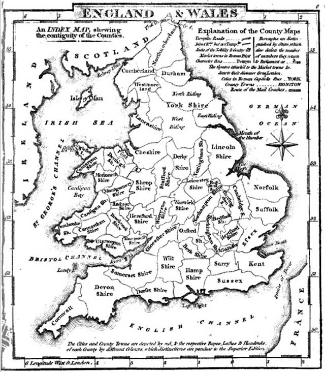
A brief history of administrative geography
The shire or county is an administrative unit used to manage tax collection, the raising of military forces, administration and enforcement of justice, local government and parliamentary representation. The nature of shires and how they were set up has been complicated by hundreds of years of change, different legal and government systems, and several wars of conquest and rebellion.
The evolution of administrative geography in England
The Romans were the first to take constantly changing tribal territories and create administrative areas - usually defined by topographical and geographical features. After the Romans left, their administrative divisions fell into disuse and it was not until the 5th century that the areas that would become the English counties started to take shape.
As smaller kingdoms rose and fell, and Saxon and Danish raiders put down roots, the 7 kingdoms of England of the 7th century became a single English kingdom in 927 AD. The resulting kingdom was subdivided into a number of shires by the middle of the 11th century. The feudal system, introduced by the Normans, changed local government, taxation and justice. The shires (administered by a Sheriff) became counties (areas under the control of a count).
Counties were subdivided to ease administration burdens, for example Yorkshire has the North, East, and West Ridings. These larger areas were further split into smaller elements known as Hundreds in most counties, Wapontakes here in Yorkshire, Lincolnshire and Nottinghamshire, and Wards in Durham, Northumberland, Cumberland and Westmorland. A Hundred (or its equivalent) was divided into tithings and parishes, which, were in turn, divided into townships and manors.
The evolution of administrative geography in Scotland
The first Scottish shires were created in the 11th century, as previous forms of government were replaced with Norman feudal structures, and the process was complete by the middle of the 12th century. By the middle of the 17th century, the remaining shires were formed by territorial expansion or subdivision of existing shires, and they started to be used for local administration and judicial purposes. The 1707 Act of Union started a process of bringing Scottish local governance into line with the rest of Great Britain. By the end of the 18th century the Scottish county system matched that of England, Wales, and Ireland.
To further complicate things in Scotland, the burgh, an autonomous municipal corporation, was used for local administration. A burgh was typically a settlement with a castle and a marketplace. By 1516 there were over a hundred burghs used for administration as well as local and international trade and commerce. Burghs had rights of representation in the Parliament of Scotland and after the Act of Union many became Parliamentary burghs represented in the Parliament of Great Britain. Burghs sat alongside, but were not part of, the county system.
The evolution of administrative geography in Wales
The Normans began the move towards rational administrative areas with the creation of marcher lordships, such as Glamorgan, which served as semi-autonomous administrative divisions. However, counties in the strict sense first appeared in Wales in the 13th century and were only completed under the Act of Union 1536. Many of these counties were created from existing marcher lordships.
The creation of modern administrative geography
The end of the 19th century saw changes to establish local government through counties. Historical counties were reformed as “administrative counties” and larger towns and cities became “county boroughs”. At the start of the 20th century the systems of local government and associated geographies were very similar across the United Kingdom. However, changes continue into the 21st century with a modern trend for consolidation from the two tier county/district model into “unitary authorities” - or “super districts” in Northern Ireland.
We are always happy to talk about how using administrative geography can help your analysis. Email info@beacon-dodsworth.co.uk and see how we can help your business.