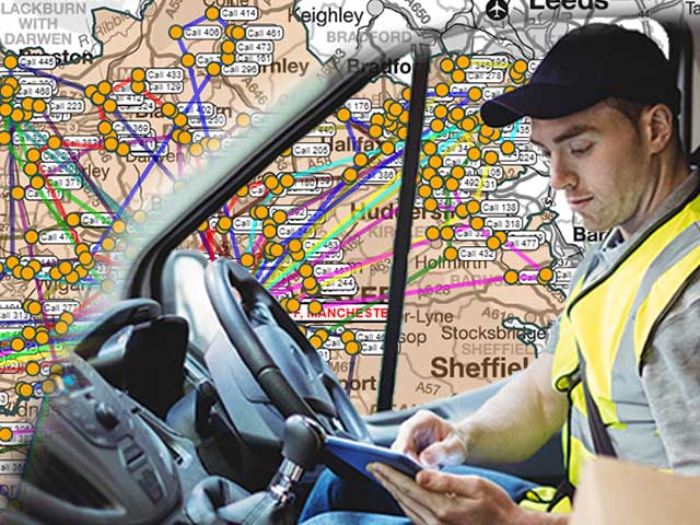
TimeTravel: efficient business travel on today’s road network
The cost of getting from A to B by road is going up, so finding the most efficient route for your drivers and representatives is more important than ever. The latest update to our TimeTravel drive time and distance data gives businesses the tools they need to make their staff travel as efficient as possible.
What is TimeTravel?
TimeTravel is our dataset of drive times and distances between any postcode sector or district. It provides a way to accurately plan and measure multiple journeys, whether that is for fleet, field team, or customer travel around the UK.
Working at postcode sector level means we can pre-calculate every possible sector-to-sector journey across the whole country. This removes the longer calculation times required for point-to-point calculations and makes it practical to implement in systems where a quick response is required for multiple users.
One of the main strengths of TimeTravel is that it uses up-to-date data to make realistic journey times. With road network and postcode geography constantly changing, our clients should ensure that they update the data they use every year to get the most accurate results from the tool.
So how does TimeTravel work and how does the latest update improve it?
How we calculate realistic travel times
To make otherwise complex calculations simple to the end user, we use the following process for each TimeTravel update:
- We locate the population weighted centroid of each sector to use as a drive start point. This means that the most frequent journeys are represented because most start points will be from the major population centre in the sector.
- For each source sector, we calculate the time to drive to every piece of road that is navigable - usually every junction on the same landmass.
- In every destination sector, we calculate the drive time to all the road junctions in the sector and average the time taken.
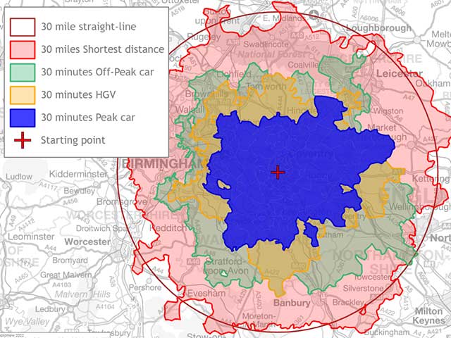
- We then calculate the fastest (shortest time) journey time and distance using peak, off-peak, and HGV speed tables.
The journey distance is the distance of the fastest route rather than the shortest distance. This is because the shortest distance is the absolute minimum distance possible and does not take into account different road types or conditions. However, the shortest distance is available within the data to those for whom mileage is more important than time.
Journey planning to UK islands
Changes to journey planning in 2023
UK road network
The UK road network is constantly being revised, so any reliable travel planning needs to use up-to-date data. The road network we use for mainland UK is supplied by Ordnance Survey (OS). With their reputation for accuracy, using OS data at the heart of TimeTravel allows for the most current snapshot of the UK’s travel infrastructure. We also update vehicle classification and speed models of the latest road network.
Changes to postcode geography
Royal Mail are constantly changing their postcode geography to match the changing residential and business composition of the UK. They need to add in new sectors to allow for new housing and business developments, whilst removing retired postcodes as larger businesses close, buildings are demolished, or areas reclassified. The latest TimeTravel data includes 17,825 postcode unit changes that have taken place since the previous update made up of 10,595 new and 7,230 terminated postcodes.
As well as the unit postcodes that we use for letters and pizza delivery, many businesses have postcodes called large-user postcodes. Where we can, we append these postcode sectors to the database making the total number of sectors 11,125 in this release. Sometimes the group of postcodes that form a logical sector are not contiguous enough (closely grouped) to represent a single unit so we exclude them.
In addition to individual postcodes, many postcode sector boundaries have been updated. The knock-on effect for journey planning is that both the source (the "centroid" that we use, weighted by population) and the target (the reachable junctions) will have changed for many sectors. All of these factors will affect the sector to sector drive times used in our calculations.
Longest road journeys in the UK
We like to keep an eye on the outliers in our updates and this year’s has highlighted a couple of extremes in travel statistics.
- The award for most isolated sector (i.e. the sector where you need to travel furthest from the centroid to get to a neighbouring sector) falls to IV27 4.
- The longest peak time journey you can make is between HS5 3 and TR19 7 and would take you 1345 minutes. It is also the longest distance at 1377.4 km.
How is TimeTravel data supplied?
The full TimeTravel dataset for the whole of the UK and maximum detail comes in at almost 124 million data rows in the latest version and is almost 4 gigabytes in size. However, TimeTravel data is scalable to meet your specific geographic and detail needs, so the version you receive is likely to be a compressed .txt or .csv file via FTP or Google Drive transfer. The data is too large to be seen in its entirety in Excel or Access and is more likely to be integrated into an enterprise database, a CRM, or website for use in staff or customer-facing travel tools.
If you prefer, we host the data on a server with an API interface to allow it to be available 24/7 to support your staff or customers. The API provides TimeTravel data online with the convenience of avoiding large downloads, database loading, and annual updates. In addition, it can provide a richer and more efficient set of common request types. We have a demo account to showcase this functionality at work, so get in touch if you’d like a demonstration.
Our existing TimeTravel clients benefit from an annual TimeTravel update. So, if you are an existing client, we will be in touch very soon about how you can get hold of the latest version. If you are considering TimeTravel for your own business, please email info@beacon-dodsworth.co.uk and we can talk through your requirements and the data’s capabilities in detail. We can also share a sample of the data with you to ensure that it meets your needs.