Postcodes: how do they work and what can they do for us?
We all (should) use postcodes. That handy series of letters and numbers coupled with a building name or number is all that is needed to get deliveries to our door. Unlike many other postcode systems, U.K. postcodes are easy to decode and geographically descriptive. Since their widespread introduction almost 50 years ago, postcodes have been used to get deliveries to the correct address, describe areas and localities, and as an effective way to geocode and map other data.
A brief history of the humble postcode:
When and why were postcodes introduced?
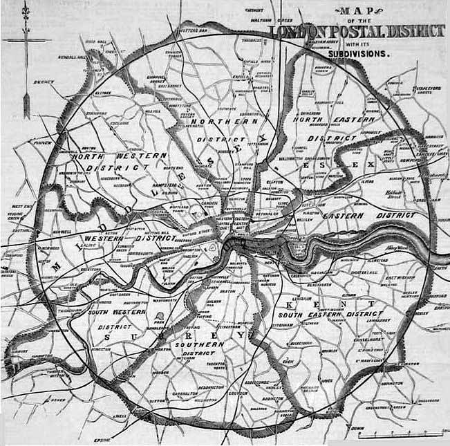
It all started during the reign of Queen Victoria. London’s population grew rapidly throughout the 19th century. In 1800 the population was just over 1 million, but by 1900 the population was over 6 million. The amount of post carried reflected the rise in population. In 1854 The Postmaster General, Charles Canning, set up a committee to investigate how best to divide London in order to route and distribute mail more efficiently.
The problem was not trivial, in 1856 the London population of about 3 million received 100 million items of post. The project, managed by Sir Rowland Hill, came up with a nearly circular area drawn 12 miles around the central post office near St Paul’s Cathedral. This was divided into 10 districts.
A timeline of key postcode developments:
-
1857/8: London is divided into 10 districts
East Central (EC), West Central (WC), North (N), North East (NE), East (E), South East (SE), South (S), South West (SW), West (W) and North West (NW). - 1864/5: Liverpool split into Northern, Eastern, Southern, and Western districts.
- 1866: London NE merged with London E district.
- 1867/8: Manchester and Salford split into 8 numbered districts.
- 1868: London S district split between London SE and London SW.
- 1917: London postal districts split into numbered sub districts to improve efficiency.
- 1934: Numbered districts introduced into “every provincial town in the United Kingdom large enough to justify it”: Birmingham, Brighton and Hove, Bristol, Edinburgh, Glasgow, Leeds and Bradford, Liverpool, Manchester and Salford, Newcastle upon Tyne, and Sheffield..
- After 1945: Mail volumes grow. A postcode system was needed to facilitate automated sorting.
- 1959: Norwich selected to trial a postcode system as they had eight new automated sorting machines.
- Early 1960's: The Royal Mail starts a mechanisation program to introduce reliable mechanical sorting. Sorting machines needed the address to be machine-readable, so a code system was developed from the Norwich trials.
- 1965: The Postmaster General, Tony Benn MP, announced postal coding would extend to the whole of the UK over the next few years.
- 1967: New postal codes introduced in Croydon.
- 1967-1970: Rollout of new codes to major centres: Aberdeen, Belfast, Brighton, Bristol, Bromley, Cardiff, Coventry, Manchester, Newcastle upon Tyne, Newport, Reading, Sheffield, Southampton and the Western district of London..
- 1971: Addresses receive notification of their own postcodes.
- 1974: Coding is completed. Norwich is the last place to be re-coded.
How does the modern UK postcode system work?
So how does this collection of letters and numbers fit together to make a rational and reliable system?
Put simply, the first half of the postcode is the “outbound” code, allowing a letter to be sent to the correct part of the country; this is made up of between two and four alphanumeric characters.
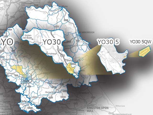
The second part, the “inbound” code, is then used to pinpoint the exact neighbourhood and postal round it needs to go to; this always follows a space and has three alphanumeric characters. Let's take a look at an example:
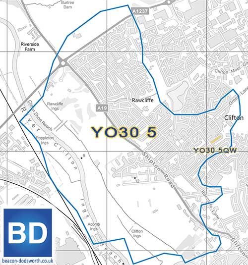
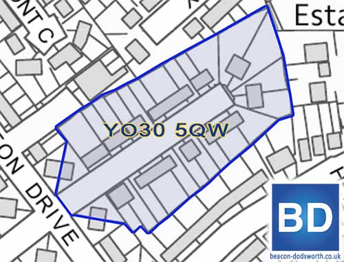
Example: the elements of postcode YO30 5QW
Outward code- Area: YO: One or two alpha characters subdividing the country
- District: 30: One or two alphanumeric characters subdividing the area
- Sector: 5: One numeric character subdividing the district
- Unit: QW: Two alpha characters showing a group of buildings, a street, part of a street or a single delivery point
Of course each element has a lot more too it than that, so let's look at each in more detail from largest to smallest. Please keep in mind that the postcode network is constantly changing and this data is just a snapshot at the time of writing - June 2023.
1) Postcode Area
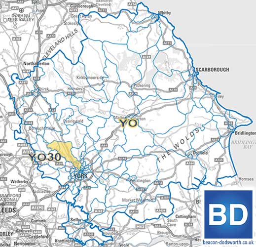
125 postcode areas cover the United Kingdom, with each varying in size and population. They are usually named as a mnemonic to identify the area or Post Town they cover. E.g. AB: Aberdeen and YO: York. Most of the names are obvious but there are some mismatches, for example Rochester in Kent has an area code of ME for Medway and Lerwick in Shetland has a code of ZE for Zetland (an archaic spelling of Shetland).
London developed a postal code system in the 19th century, so area codes in London are taken from the earlier system. E.g. N: North London, WC: West Central London.
- Smallest size WC, West Central London (1 square mile ).
- Largest size IV, Inverness (6,243 square miles).
- Average size 776 square miles.
- Smallest population ZE, Shetland (22,940 people).
- Largest population B, Birmingham (2,026,552 people).
- Average population 553,546.
- Smallest number of districts in an area ZE, Shetland (3).
- Largest number of districts in an area BT, Belfast (80).
- Average number of districts in an area 24.
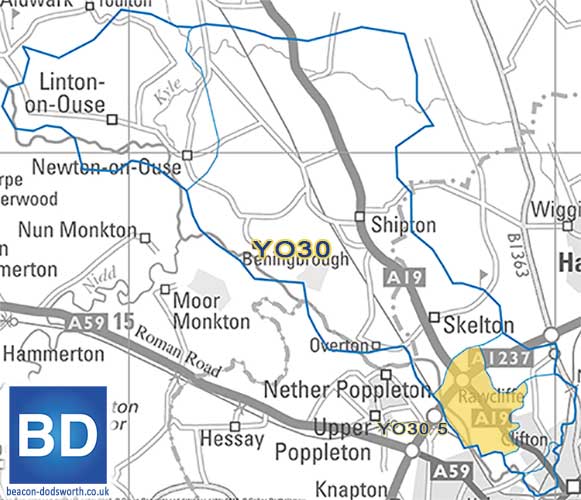
2) Postcode District
2,977 postal districts cover the UK. Postcode Districts are used to subdivide postal areas and help route mail to its sorting office.
Districts fall into areas. On average there are 24 districts in an area. The actual number varies between 3 and 77. Each one varies in size and population quite considerably.
- Smallest size is EC2N, East Central London (0.03 square miles ).
- Largest size is IV27, (1,393 square miles).
- Average size 33 square miles.
- Smallest population PA63,Loch Spelve, Mull (15).
- Largest population CR 0, Croydon (170,937).
- Average population 23,793.
3) Postcode Sector
The UK has 11,241 postal sectors. Sectors are used in the inbound code to help pick the delivery round. There are between 1 and 10 sectors to make a district. On average each district has 4 sectors.
- Smallest size EC3A 1, London, (less than 0.001 square miles).
- Largest size IV27 4, Lairg, Sutherland, (1,393 square miles).
- Average size 9.7 square miles.
- Smallest population WC2R 2, St. James’s, London (01).
- Largest population E14 9, Millwall, London ( 26,345).
- Average population 7,041.
4) Postcode Unit
A unit postcode describes a street or part of street, a single address, a group of properties, a subsection of a property or an individual organisation or department within an organisation. There are more than 1.7 million (1,794,832 in June 2023) unit postcodes. This number changes regularly as around 2,750 postcodes are created and 2,500 are terminated each month.
The allocation of postcodes depends on the amount of mail received. Large users of mail such as the DVLA have different postcodes for different departments. The unit postcodes are used to find about 30 million actual addresses or delivery points, the minimum number of delivery points for a postcode is one, the maximum is 100, and on average the postcode is allocated to 15 delivery points.
There are on average 159 postcodes to each sector: the most being 397, the least is 1. The theoretical maximum is 400 because the last two letters are not allowed to be any of C, I, K, M, O, V. That leaves 20 for each letter.
Postcodes, not just for post
Since their inception, postcodes have become more than just a tool to help address mail. As postcodes nest into sectors, districts and areas, the postcode has become a handy label to define geographical locations.
Demographic Profiling:
Postcode boundaries provide a convenient way to tie people into manageable groups with similar lifestyles and outlooks to form the building blocks of geodemographic analysis.
Postcode mapping and geographic analysis:
Although postcodes focus on addresses, their aggregated groupings and boundaries provide an ideal building block for geographic analysis. Most businesses have data that is attached to postcode information. This could be customer records, or sales receipts for a store where the customers are most likely to travel to. Having data attached to postcodes opens up analysis and comparisons using census or other demographic data. Our own GIS systems can use postcodes as their geographical key.
p>Journey and logistics planning:
Postcodes are a far more accessible reference than coordinates or longitude and latitude making them ideal for setting departure and destination points in navigation tools. However, the sheer number of postcodes means that when you move beyond individual journeys, for business or fleet logistics planning the calculations required quickly become unmanageable.
Alternatives to postcodes: the geography of government
Despite their history, postcodes are comparatively new, and the UK government had already developed its own way of dividing the country into manageable administrative areas – imaginatively called “Administrative Geography”. In existence in some form for more than 1,000 years, the divisions are based on long-standing counties and parish boundaries, which have themselves changed and been sub-divided over the centuries.
These boundaries do not correspond to postcode geography very accurately and it is not unusual for a postcode area to seem misleading when you consider the county on an address, for example; the NR postcode (Norwich) doesn’t mean that you necessarily live in the Norfolk administrative county. As such, The Office for National Statistics (ONS) produces a directory of all current and terminated UK postcodes matched against the various UK administrative geographies. This reference source ties postcodes to census and other demographic datasets.
As you can see, postcodes have developed into far more than just a means of directing your post, they have become a fundamental building block for navigation, logistics and economic operation. Postcode mapping for business is what we do, so forgive us if we seem a little too passionate about the subject, but I'm sure you'll agree, there really is a lot to the humble postcode. Email [email protected] and see if postcode mapping can help your business.