The power of postcode sectors
We all know our postcode, or at least we should do. It is an integral part of our address, making routing our mail (and increasingly, other deliveries) more efficient, and guiding SatNavs. Part of the power of the postcode comes because individual, full postcodes (e.g. YO23 2BD) are the building blocks of larger units: postcode sectors (e.g. YO23 2), districts (e.g. YO23) and areas (e.g. YO). They form a neat hierarchy - see our postcode blog for more on this.
Often our postcode is shared by a few neighbours (on average about 15). A postcode is a collection of addresses, usually on a single street, normally forming a natural group or cluster. The postcode sector is the most practical reporting/aggregated unit - small enough to give geographical detail but large enough to show some homogeneous behaviour and reveal national patterns.
Creating meaningful boundaries
Postview, Beacon Dodsworth’s postcode boundary product brings together raw postcode data into these meaningful analytical areas. It forms the backbone of some of our other products, for example Prospex for mapping, and TimeTravel for drive time lookups and Where’s My Nearest applications. It is also added in to some of our other clients' GIS systems to provide a foundation for robust area analysis.
Our product is based around The National Statistics Postcode Directory (NSPD), created by the Office for National Statistics (ONS). It supplies a single location for each postcode (equivalent of Ordnance Survey CodePoint Open). This is usually the location of the single address that is closest to the centroid of all the addresses that share that postcode. When we look at a group of postcodes with the same code except for the last two letters (i.e. all the postcodes in a single postcode sector) we see that they naturally form an area with a fairly clear boundary.
If we compute the boundaries for all the 11,200 or so postcode sectors we will have the basis for mapping and analysis.
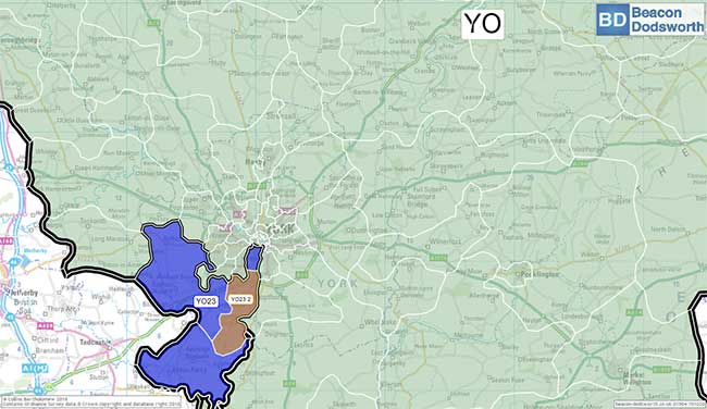
The YO postcode area with an example district (YO23), and sector (YO23 2)

The postcodes that form the YO23 2 postcode sector.

Not all sectors are so easy to define, such as SW18 1, shown here.
The difficulties of defining boundaries
Of course it isn’t easy, there are several complicating factors:
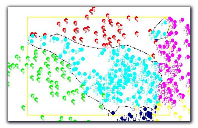
1. Where postcodes meet very closely, the boundary has to "weave" between two dense sets of points. For example the maps below shows groups of postcodes that appear easy to put a boundary around, until you zoom in and see how complex the boundary really is.

Weaving a boundary between densely-packed postcodes can prove difficult...

...especially when you zoom in and see how complex the postcode network can be.
2. Where postcodes are very spread-out, imposing a boundary can seem very arbitrary. For example, in the image below, should the grey dots form an "island" within the blue dots? Equally, where postcodes overlap, it is difficult to find a best fit that works for both accuracy and aesthetics.

Widely-spaced postcodes: should the grey points above form an island, or run flush with the neighbouring green point set.
3. Inaccurate locations - these are identified as "lone" postcodes inside another sector, for example, should the light blue rogue location to the right be an "island"?
4. Changes over time such as: improved accuracy of co-ordinates, new builds, demolition, reassignment - when a postcode is altered by Royal Mail, and reuse - when an "old" postcode is brought back into use at a different location.
Sometime there are not enough available postcodes for a sector. Because of the naming convention where the last two letters identify the postcode, there are only 400 available distinct postcodes (the letters C, I, K, M, O and V are not used because of easy confusion with other letters for automatic sorters and humans). In this case a new postcode sector is created. Sometimes the Royal Mail split a sector into two or more new ones.
From PostView’s point of view, new sectors emerge gradually as co-ordinate information is inserted into the NSPD. The first version of PostView, more than 20 years ago, had 8,400 postcode sectors. We now have 11,224 (as at November 2020).
5. "Large users", usually businesses, provide their own forms of complexity. A large complex, with its own postcode may exist inside the boundary of a residential postcode sector. Alternatively, their postcode may only be loosely related to their nominal sector, or they may be entirely stand-alone with no equivalent residential postcodes sharing their sector.
6. The coast forms a natural boundary for some sectors, but which coastline should we use? There are several suppliers of mapping information whose coastlines differ slightly. There is not always a single coastline from any one supplier but variations dependent upon tides - high, low and mean water levels. Sometimes details such as piers and docks appear in detail, sometimes not. We have “stitched” on the detailed Ordnance Survey Open Data Boundary Line coastline, which is Mean Low Water. This has the advantage of overlaying well with other OS background maps and it can be generalised (reproduced at a lower resolution, with fewer “wriggles”) for more rapid display (e.g. for online mapping).
7. Postcode sectors whose postcodes have not yet been assigned coordinates.
8. The Channel Islands: Jersey (JE) Guernsey (GY), and the Isle of Man (IM) have a postcode system but full postcode co-ordinates are not published. We have created sectors from locality information and royalty-free maps. For mapping convenience we have transposed the Channel Islands north in the English Channel.
Because of the changes over time we run a regular health check to identify sectors whose constituent postcodes lie outside their boundary. We amend the boundaries where the changes have been greatest, to ensure that Postview is as accurate as we can make it. For example, we recently edited well over 500 sectors and continuously review the position of the sector, district and area labels to optimise the aesthetic quality of the mapping display at most scales.
Call 01904 701020, complete Contact Form or Sign Up
Above: The light blue is one sector, but the separate "island" of light blue makes defining one boundary tricky.
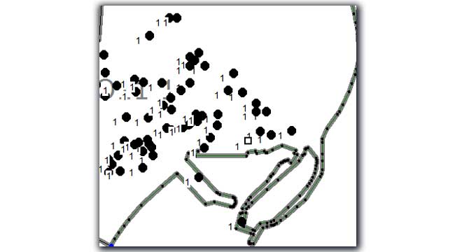
Above: Postcodes in a sector at Scarborough. Note the one on the pier.
Our other blogs
British Population Survey (BPS)
The British Population Survey (BPS) is a survey of household income and shopping habits collected by face-to-face interviews. We take a look at the BPS in detail, what exactly it is made from and how its data can be usefully applied by businesses and public organisations.
What is geodemographic profiling?
More than 64 million people live in the UK, each with their own outlook, priorities, needs and way of life. Geodemographic profiling offers a way to group these individuals to try and identify the right audience for your product or service.
The census helps you to understand your customers
The UK Census 2021: what it is, how is it made, and how can it be used to help your organisation with demographic analysis.
Using geographic intelligence to grow the UK’s broadband network
Using geographic intelligence to sustainably grow the UK’s broadband network.
Mapping efficient sales territories
We've worked with mapping, demographic, and travel data for a long time, and have become specialists in territory mapping. So we'd like to share a few tips on how best to define sales catchments for your team, or embark on territory review.
TimeTravel: the latest update
We look at the latest update to TimeTravel, our dataset of drive times and distances between any postcode sector or district. What has changed in the UK road and geographic network, plus new features to make it even more accurate.
How to create a postcode map
Turning a list or spreadsheet of postcode data into a series of points on a map isn't as simple as using an Excel wizard to do it for you, but it isn't rocket science. We look at the best way to create a postcode point/pin map.
Living Costs and Food Survey
The Living Costs and Food survey (LCF) is compiled every year and is used by the UK and European governments, Department for Transport (DfT), and Her Majesty’s Revenue and the Customs (HMRC). But what is it, and why should we care?
Cycle to work day
Each year for #cycletoworkday we take a look at cycling statistics across the country and try to map that data and find interesting trends. This is mainly because we at Beacon Dodsworth are either a little bit obsessed about cycling, or we tend to worry about the environment.
Mapping for local projects
Recently, we were contacted by a company responsible for organising charity door knockers. They needed more than 9,000 postcode sectors mapped at A4 size to use at a local level to plan fundraising routes and clearly define territories for each agent.
Social change over 10 years
With the next census due to take place this year, we thought it was a good time to take stock of some of the changes and trends we noticed between the 2001 and the 2011 census. What difference does 10 years make to our society and the people that live within it?
Beacon Dodsworth New Office
Now we are back in the office, we continue to support hybrid working. So, we’ve taken the opportunity to downsize our office to make us more resilient to future lockdowns, staff self-isolation, and any other uncertainty the modern world might throw our way.
Postcode to postcode drive time and distance
What happens if we want a postcode to postcode drive time lookup table?
Administrative Geography
Administrative geography is a way of dividing the country into smaller sub-divisions or areas that correspond with the area of responsibility of local authorities and government bodies. We take a look at administrative geography, what it is and how to use it.
Who spends most on Fruit and Veg
National Vegetarian Week (#NationalVegetarianWeek) this year ran from 10th to 16th May. It gave us the opportunity to highlight how GIS mapping can be used to create marketing campaigns and raise awareness of the benefits of eating more fruit and veg.
Data visualisation and colour blindness
John, our director talks about living and working with colour blindness in the mapping industry where colours are pivotal in adding dimensions to people's understanding.
How far is it to the beach
We use Beacon Dodsworth's scripting technology to answer that most important of questions when the sun finally does threaten an appearance.
All you need to know about postcodes but were afraid to ask
The humble postcode has been around for years. We look at how postcodes are used and what led to their introduction.
Yorkshire Day
As a Yorkshire-based company, we wanted to help celebrate Yorkshire Day, which takes place on 1st August. Naturally, we wanted to put a geographic spin on the celebration, so we took a look at drinking preferences within God’s own county.
The foundations of geographical analysis
Displaying data on maps makes it easier to understand as well as giving a new perspective on a problem. Using a GIS to prepare and present data has become increasingly popular over the last 20 years, but graphical displays of data on maps were around long before computers came along.
How to back up your Prospex data
Keep your GIS projects safe by using the in-built Prospex back up process. Here is how.
The power of postcode sectors
Postcode sectors are aggregations of individual postcodes and they provide meaningful geographical reporting areas in any GIS. However, they aren't as easy to map as you might think. Here is how we do it.
The new normal for the GIS world
Toby, our Account Manager, looks at the changes to working style and client needs in the geodata industry following the COVID-19 outbreak.
Where is the North
We've used the territory manager tool in Prospex GIS to split the UK into north, south and east and west with equal population counts.
What is GIS software?
A Geographical Information System (GIS), is a tool for analysing, visualising, managing and presenting data that is related to a physical, geographical location. That link to geography is the key difference between GIS and other data visualisation techniques.
Mapping GP prescription data
An article by Allan Brimicombe (Head of Centre for Geo-Information Studies at the University of East London) & Pat Mungroo on using GP prescription data to understand health needs.
Geodemographics and the University of East London
The University of East London explain how they have been using our P² People & Places geodemographic classification.
Google Fusion Tables
After almost 10 years of service, Google retired their Fusion Tables product at the end of 2019. This tool was very useful at visualising and sharing large amounts of tabular data - particularly amongst small and mid-sized businesses. So what can we do to fill the gap left by this tool?
Call 01904 701020, complete Contact Form or Sign Up
 Sign up for our newsletter
Use of cookies
The Beacon Dodsworth site uses cookies to improve your user experience and to provide analysis of how our site is used.
Your continued use of this site is taken as implied consent to receive cookies from us and our analytics partners.