Client case studies
Some examples of how our software, data, and expertise have delivered solutions to real-world, location-based business challenges.
Thatchers: territory management with MapVision
Thatchers Cider are a well-known family-run business tending over 500 acres of orchard and creating cider since 1904. Based at Myrtle Farm at the foot of the Mendip Hills, Somerset, Thatchers came to us to map their sales territories and help them to grow their presence outside of their South West heartland.
NHS Healthcare Trust: choosing clinic location by travel time
A regional Healthcare Trust provides emergency and non-emergency services to the residents across one, or often several counties. In addition to the in-patient services provided at core hospital facilities, they also need to offer a range of outpatient and diagnostic services across their region. One such NHS Healthcare Trust approached us to assist them in a project to intelligently plan the location of these outpatient clinics.
The RAF Benevolent Fund: helping more people with national understanding
The Royal Air Force Benevolent Fund (the Fund) are an independent charity assisting serving and former RAF personnel and their families. They came to us to gain a better understanding of the national demand for their services in order to allocate resources effectively and predict future requirements.
Vibrant: territory gap analysis and local consultant selection
Vibrant Energy Matters Limited (Vibrant) is the UK’s largest property services company. They provide outsourced solutions to residential lettings and sales agents, private landlords, commercial agents, property managers, and social housing providers. Vibrant approached us looking to optimise their staff network and improve their service efficiency.
ASP Hair use MapVision to connect clients with their closest distributor
International Hair Cosmetics Limited are a global name in haircare products. Since 2012 their sales support team have been using our solutions to make it as easy as possible for their UK clients to source ASP Hair branded products from the most conveniently located distributor.
Northamptonshire County Council use P² People & Places to better target their services

Northamptonshire County Council (NCC), like every council, have the daunting task of distributing their resources in the most efficient way to benefit residents. They approached us looking for a geodemographic profiling solution to help them to improve service provision and, most importantly, the health and wellbeing of the population of Northamptonshire. We suggested P² People & Places (P²), our own geodemographic profiling data based on census and lifestyle data.
Stuart Todd Associates simplify town planning with MapVision
Stuart Todd Associates Ltd provide independent town planning services at the neighbourhood, local and strategic levels. A small consultancy, with almost 25 years of planning expertise and professional support and an enviable client base spanning the public, private and community sectors, Director, Stuart Todd, approached us looking for a cost effective and simple GIS mapping tool with a wish list to include administrative boundaries and drive-time catchments, whilst retaining simplicity of use.
RSAcademics offers greater value to their clients with mapping consultancy

RSAcademics is an educational consultancy offering strategic marketing and research to schools. They provide a range of strategic marketing and research services to support school leadership teams with their pupil recruitment and retention. Since they were founded in 2002, they have advised and supported over 700 schools and educational organisations worldwide. Our mapping consultancy services help to supplement their considerable expertise in the schools’ sector.
Customer analysis finds new locations
Vision Express wanted to expand their portfolio of stores and customers. To find out where to locate new stores they needed to understand the consumer characteristics of their existing store catchments. Here is how we worked together.
Call scheduling software and managing field force visits
Since 2007 Tactical Solutions have successfully used Prospex, our fully featured GIS software, to efficiently plan and schedule client visits. Tactical Solutions operate a field sales service with a team of representatives (reps) routinely visiting over 1,650 retail outlets. They work with in-store teams to find and fix all stock replenishment issues for supermarkets such as ASDA and Tesco, plus other household names like Duracell, Innocent, Quorn and Birds Eye.
RAC use TimeTravel drive time data
With a long history and over 8 million members RAC is one of the UK’s most popular motoring organisations. They are committed to making motoring life easier and more affordable for their members. For several years RAC have successfully utilised TimeTravel; our comprehensive drive time data matrix, to enhance customer service and manage their approved garage network.
Bespoke interactive mapping of journeys on England’s major road network
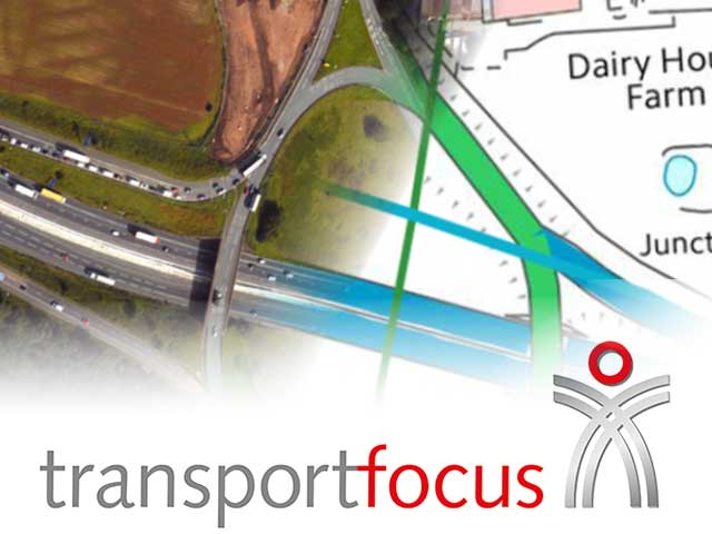
Transport Focus, the independent watchdog for transport users, set out to develop a survey for Strategic Road Network (SRN) users which measured satisfaction specific to the SRN roads they used. A key challenge in SRUS design was identifying the SRN roads the users had travelled on, and which Highways England Areas they had travelled through.
Lambert Smith Hampton - native location intelligence
Lambert Smith Hampton (LSH) is a leading, progressive, property consultancy working across the UK and Ireland. They work with a diverse portfolio of clients and manage thousands of retail, commercial, and residential properties. When LSH approached us, they were looking to be able to create heat maps at a local authority level and then embed the results within their website to make them available to everyone.
Measuring journey distances for drivers with disabilities

A registered charity approached us with a challenge. They needed a way to measure journey distance for both their own car-using customers and the HGV drivers distributing these vehicles. The solution needed to present accurate distances to ensure that customers weren’t left out-of-pocket, and allow for the lowest running costs for the charity itself. It needed to integrate into their current systems using a bespoke API and support a potentially high-volume of individual journey calculations.
Rexel UK - batch producing maps and site territories
Rexel UK came to Beacon Dodsworth looking to allocate territories to their branches throughout Great Britain and Northern Ireland. Here is how we worked together to maximise the efficiency of each branch in their network.
How can we help you?
We are happy to act as an outsourced GIS mapping team or supplement the expertise of your own team.
Why not see what we can do for you.
Contact us